A massive tsunami alert erupted across the Pacific Rim on July 30, 2025, after a catastrophic magnitude 8.8 earthquake struck off Russia’s Kamchatka Peninsula. This historic quake—tied for the sixth-strongest ever recorded—triggered urgent tsunami warnings from Japan to California, forcing over 2 million evacuations and disrupting travel, infrastructure, and daily life. The shallow temblor, centered just 136 km east of Petropavlovsk-Kamchatsky, unleashed waves up to 4 meters (13 feet) in Russia, with ripple effects felt globally
Kamchatka: Ground Zero of the Seismic Event
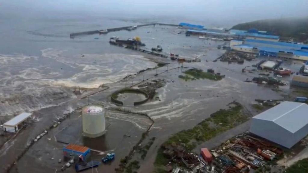
The Russian earthquake today devastated the remote Kamchatka region, a hotspot on the Pacific Ring of Fire. Key impacts include:
-
Infrastructure Damage: Waves flooded Severo-Kurilsk’s port, destroyed a fish processing facility, and damaged power grids in Sakhalin. A local kindergarten collapsed, and a woman was injured after leaping from a building during panic .
-
Heroic Resilience: Surgeons at Kamchatka Cancer Center continued operating as the quake rattled their facility—a moment captured in viral footage .
-
Historical Parallels: This quake echoes the 1952 Kamchatka magnitude 9.0 event, which sent 30-foot waves to Hawaii. Experts note the region’s low population density likely prevented higher casualties .
Japan Tsunami 2025: Evacuations and Near Misses
Japan’s Pacific coast faced the most extensive evacuations, with 1.9 million people across 21 prefectures ordered to higher ground. Critical developments:
-
Wave Impacts: A 1.3-meter (4.3-foot) wave hit Kuji Port (Iwate Prefecture)—the largest in Japan—while smaller surges reached Hokkaido and Miyagi. Though below initial 3-meter forecasts, officials warned of multiday risks due to tidal cycles .
-
Nuclear Precautions: Workers at Fukushima’s nuclear plants evacuated, halting radioactive wastewater discharges. No abnormalities were detected, a relief after the 2011 disaster .
-
Transport Chaos: Sendai Airport shut runways, while rail lines like Tokaido and Shonan-Shinjuku suspended service. Only one minor injury (a woman in her 60s) was reported nationwide .
Hawaii Tsunami: Waves Hit Amid Travel Turmoil
Hawaii’s nightmare scenario unfolded as waves coincided with high tide:
-
Coastal Flooding: A 1.5-meter (5-foot) surge inundated Kahului (Maui), while Hilo saw flooding. Waves receded rapidly, exposing reef flats—a classic tsunami precursor .
-
Airport Crisis: Hilo Airport closed to allow coastal evacuations via its runway. All Maui flights were canceled, stranding 200 travelers overnight. Hawaiian Airlines resumed operations only after alerts downgraded.
-
Downgraded Alert: The Pacific Tsunami Warning Center lifted its “warning” by 10:39 p.m. HST, citing passed peak danger. Officials urged continued coastal avoidance due to lingering currents .
US West Coast and Pacific: Ripple Effects
Tsunami energy radiated across the ocean:
-
California: 3.5-foot waves slammed Crescent City—a tsunami-vulnerable hotspot—while Arena Cove saw 1.6-foot surges. The Bay Area reported “dangerous currents” with 2.5-foot tidal swings in 15 minutes .
-
Alaska & Washington: Advisories covered Aleutian Islands, with La Push and Westport recording initial waves.
-
French Polynesia on Edge: The Marquesas Islands braced for 4-meter (13-foot) waves, prompting France’s military to standby for rescue ops .
Table: Confirmed Tsunami Wave Heights
| Location | Wave Height | Source |
|---|---|---|
| Kamchatka, Russia | 3–4 meters (10–13 ft) | Regional Emergency Ministry |
| Kuji Port, Japan | 1.3 meters (4.3 ft) | Japan Meteorological Agency |
| Kahului, Hawaii | 1.5 meters (5 ft) | NOAA |
| Crescent City, CA | 1.1 meters (3.6 ft) | National Tsunami Warning Center |
| French Polynesia | Up to 4 meters (13 ft) | French Polynesia Authorities |
Why This Tsunami Defied Expectations
Despite its historic magnitude, the tsunami’s impact was mitigated by three factors:
-
Epicenter Depth: At 20.7 km shallow, energy dispersed laterally rather than vertically.
-
Coastal Geography: Hawaii’s islands “wrapped” waves, reducing direct hits. Japan’s seawalls (built post-2011) blunted surges .
-
Timely Warnings: Automated alerts gave Japan 90+ minutes to evacuate. The U.S. system tracked waves in real-time, downgrading Hawaii within hours .
Table: Tsunami Response Timeline
| Time (Local) | Event |
|---|---|
| 11:25 a.m. (Kamchatka) | M8.8 earthquake strikes |
| 12:00 p.m. (Japan) | JMA issues Level 3 warning for Tohoku |
| 00:25 a.m. (Hawaii) | First waves hit; airports close |
| 10:39 p.m. (Hawaii) | Downgraded to advisory |
| Early hours (CA) | Waves peak at Crescent City |
The Long Shadow of the Pacific Ring of Fire
This event underscores the Ring of Fire’s relentless volatility:
-
Kamchatka’s Legacy: The peninsula has generated 7 of history’s 50 strongest quakes, including a 1952 M9.0 event.
-
Japan’s Vigilance: Continuous drills since 2011 saved lives. Real-time data from 160+ seafloor sensors guided evacuations.
-
Climate Change Amplification: Rising sea levels may worsen future tsunami flooding, especially during king tides .
Ongoing Threats and Global Preparedness
As of July 30, active advisories persist:
-
Japan: Hokkaido and Tohoku face extended warnings. Officials urge 24+ hours of coastal avoidance .
-
French Polynesia: The Marquesas Islands remain under 4-meter wave alerts.
-
Global Chain Reaction: Colombia evacuated Pacific coasts, while China briefly issued alerts for Shanghai before lifting them .
Vigilance in the Tsunami Era
The Kamchatka earthquake and tsunami is a stark reminder of nature’s fury—and human resilience. While damage was less catastrophic than feared, the event tested emergency systems from Tokyo to Honolulu. As Professor Chris Goldfinger (Oregon State University) noted, “Each coastline experiences site-specific responses”—a call for tailored preparedness 10. For real-time tsunami warning today updates, follow official channels like the Pacific Tsunami Warning Center and Japan Meteorological Agency.